Examination of Woodchuck (Marmota Monax) Burrowing Behavior and Relationship Between Burrow Diameter and Distance from Water
By
2015, Vol. 7 No. 10 | pg. 1/1
IN THIS ARTICLE
KEYWORDS
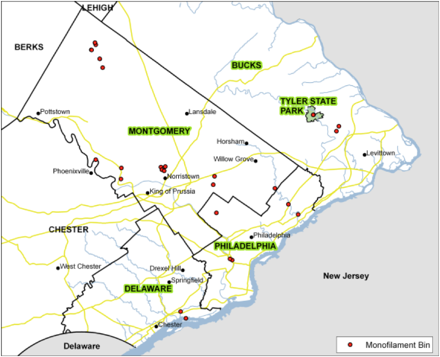
AbstractUsing data collected through field research at Tyler State Park in Pennsylvania, this study examines the characteristics of Woodchuck (Marmota monax) burrows along a creek tributary. This study finds that there is a robust positive correlation between the diameter of the burrow and this distance from the creek tributary. Using an unpaired t-test, the data was found to be significant with a p-value of 0.0003 (p< 0.05 is considered significant). A negative relationship between burrow dip angle and the distance from the creek tributary was also found and confirmed using an unpaired t-test, as the data had a p-value of 0.002 (where p< 0.05 is significant). Both of these relationships are thought to be mechanisms for limiting flood likelihood and severity when the creek tributary overflows its banks. Additionally, the data collected also gives insight into the amount of sediment displaced by burrow excavation. The average volume of sediment removed for burrow excavation for this study was found to be roughly 6.0x104cm3. However, it remains unclear exactly how much of this sediment reaches the creek tributary. IntroductionThe Woodchuck, also known as a groundhog, (Marmota monax) is an extremely common burrowing mammal throughout North America. Like many other burrowing mammals, the Woodchuck relies on its burrow for many functions and processes including “storage of food, protection from predators and shelter from the environment” (Laundre, 1989). Dimensional characteristics of the burrows, including diameter, depth and dip angle as well as directional characteristics such as azimuth and distance from a water body can indicate important functionalities the burrows help to serve. With this said, it is clear the increased data on such characteristics would not only increase the knowledge of Woodchuck life processes, but likely burrowing mammals in general. Despite this, there is little scholarship concerning the burrowing characteristics of mammals, and less concerning specifically the Woodchuck. Work on mammalian burrows and nesting habits includes Ulevicius et al. (2009), which studied the spatial distribution of beaver sites in relation to canals in a forest in Lithuania.Sawyer et al. (2012) also studied mammalian burrow characteristics by analyzing the burrowing patterns of Nine-Banded Armadillos (Dasypus novemcinctus). In addition, another emerging field of scholarship within mammalian burrow studies is the link between burrows as a source of sediment. Works in this field include Lincoln (1946); Cox and Allen (1987); Black and Montgomery (1991) and Schmidt and Elsenbeer (2014), all of which are empirical works which calculate sediment yielded from the burrows (using the volume of the burrow) and apply it as a local geomorphic agent. Hoping to contribute to the existing scholarship, the aim of this paper is to analyze the dimensional and directional characteristics of Woodchuck burrows. Using data collected from 18 burrows (10 sites) in Tyler State Park in Pennsylvania, the subsequent study will aim to correlate several variables including distance from water body and burrow diameter, burrow diameter and dip angle and the potential sediment yield from each burrow. Study AreaFigure 1 - Tyler State Park and surrounding counties.
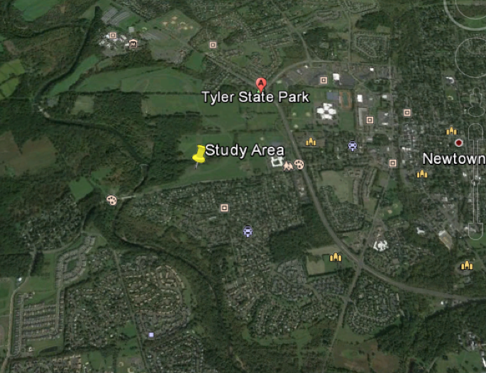
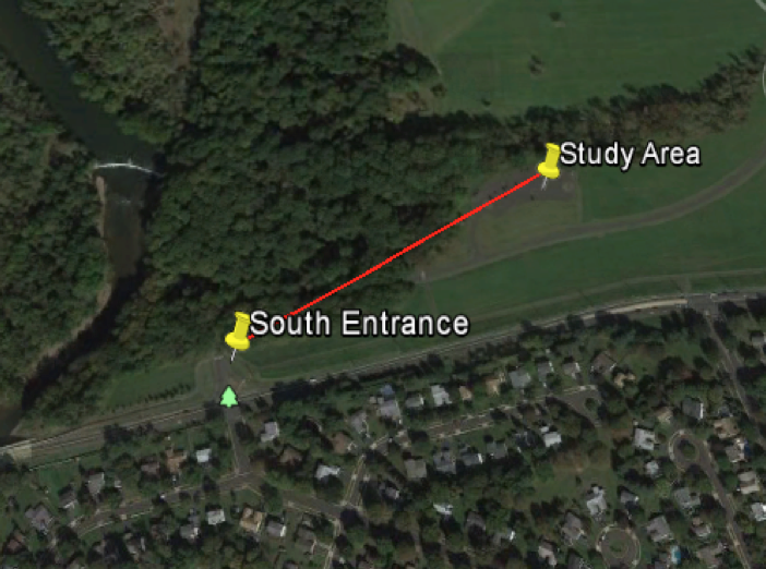
Figure 2a (top) - The study area used in the project shown in relation to Tyler State Park and Newtown. Figure 2b (bottom) - The Study area shown in proximity to the south entrance (~.3km).
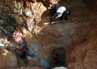
Figure 3 - The CST compactible measuring stick in burrow 3b The data used in this study was collected on Saturday October 25th, 2014 at Tyler State Park in Bucks County, Pennsylvania, approximately thirty miles NNE of Philadelphia, Pennsylvania (see figure 1).The park consists of over 1,700 acres of mainly wooded area, through which runs Neshaminy Creek, a local body of water which drains into the Delaware River approximately 15 miles to the southeast (Pennsylvania Department of Conservation and Natural Resources). Ecologically, the park is made up of three distinct habitats including forests, fields and wetlands, which are home a rich variety of species of mammals and fish. The specific area used in the study is located in the southeastern quadrant of the park, approximately a third of a kilometer ENE of the South Entrance to the park (see figure 2 a and b). MethodsThe methods used for this study are separable into two main sections, the methods used in the field collection of the data and the methods used in the lab to analyze and interpret the data gathered in the field. In the field several methods and tools were used to obtain data pertaining to the dimensional and directional characteristics of the given burrows. To measure the dimensional characteristics of the burrow (depth, diameter, distance from the bank of the water body, distance from neighboring burrows and dip angle of the burrow) a CST compactible measuring stick was used alongside an azimuth compass (see figure 3). To measure the directional characteristics of the burrows, an azimuth compass was again used. The data were recorded in the field and exported into a spreadsheet where they were subsequently analyzed using Microsoft Excel. ResultsIn sum, ten Woodchuck burrow sites were identified, resulting in a total of 18 burrows. The dimensional and directional characteristics of each burrow are summarized in the table below (see table 1). A simplified rose diagram showing how frequently the given azimuth direction occurs is also depicted (see figure 4). Table 1 - The data collected from the 10 burrow sites (18 total) showing location (where North Bank meaning the burrow was on the northern bank of the creek, a tributary of the Neshaminy, South Bank representing the southern bank of the same creek and North Bank/Gully meaning that the burrow was located on the north bank of a gully meandering out from the creek tributary.), Dip Angle, Azimuth, Diameter, Depth and Distance from the Cut Bank of the creek.
From the data tabulated above, the volume of the burrow can be calculated (using v= πr2h) if one considers the burrows to be roughly cylindrical. These calculations are shown in the table below (see Table 2). The volume of the burrow also represents the minimum entrance volume as well as the total sediment removed and theoretically added to the water body. Table 2 - Data collected from the 10 sites (18 total burrows) used to calculate the volume of the burrows.
In addition, the distance between the burrows (in each group) is shown below (see table 3). Table 3 - Distance between the burrows in each group.
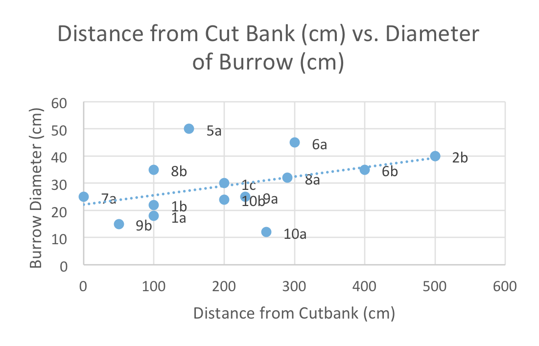
DiscussionAs iterated above, the aim of this study is to correlate several variables including distance from water body and burrow diameter, burrow diameter and dip angle and the potential sediment yield from each burrow. This is in an effort to better understand the burrowing characteristics of not only the Woodchuck, but most burrowing mammals as well. Perhaps the most robust relationship is the one that appeared from correlating the diameter of the burrow entrance to the distance from the cut bank (or water body, in this case, a tributary of Neshaminy Creek). Using a traditional unpaired t-test (p<0.05), the correlation between the two variables proved to be extremely significant, with a p-value of 0.0003. This relationship is even more robust when burrows further than 7 meters (700cm) form the bank of the creek are considered, which is shown in the graph below (see figure 5). Figure 4 - A simplified Rose Diagram showing the frequency of the azimuth of the burrows by magnitude of the “slice.” The bigger the slice, the more common the azimuth. For example, the largest slice (SW) represents the azimuth of 7 out of the 18 burrows.
Figure 5 - The correlation between distances from the cut bank (water body) and burrow diameter. The data point labels represent the site ID’s shown in Table 2.
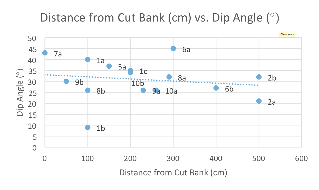
Figure 6 - The correlation between burrow distance from the cut bank (water body) and the dip angle of the burrow. The data point labels represent the site ID’s shown in table 2.
Although the literature in this field is quite limited, it would appear that burrow diameter decreases closer to the cut bank in an effort on behalf of the woodchuck, to reduce the likelihood or severity of flooding, should the creek overflow its banks. In another effort to reduce the likelihood and severity of flooding, there seems to be a correlation between the dip angle of the burrow and the distance from the cut bank. Once again, using an unpaired t-test (p<0.05), the data proved to be significant, with a p-value of 0.003. This data becomes even more significant when burrows further than 7 meters (700cm) are not considered, which is shown in the graph below (see figure 6). As mentioned above, another major implication of woodchuck burrowing (and, more generally, mammalian burrowing altogether), is the idea that sediment displaced from the burrows can become a major source of sediment for local streams and can additionally become a source of geomorphic effects in a given area (Smith and Gardner, 1985; Black and Montgomery, 1990; Imeson, 1976). Black and Montgomery (1990), noted that in a small grassland habitat in Marin County, California, burrowing activity among mammals contributed the most to sediment transport in the local ecosystem. The burrowing activity of the mammals studied contributed as much as 6.31 cm3 per year to the grassland. Perhaps the same conclusion can be drawn from the sediment displaced by the burrowing woodchucks in this study, as the total volume of sediment removed from the burrows is quite great (although how much actually makes it to the stream and how it gets there is beyond the scope of this study). ConclusionsThe aim of the study was to build on the current scholarship of the burrowing practices of burrowing mammals using the Woodchuck (Marmota monax) as an example. Through a case study of 10 burrow sites (eighteen total burrows), insights into the burrowing practices of the Woodchuck, including the dimensional and directional characteristics of the burrow were made. Using the data from the paper, two main facets of the Woodchuck burrow have become more firmly established. First, this study demonstrates that there is a robust positive relationship between the burrow diameter and the distance of the burrow from the bank of a water body, in this case, a tributary of Neshaminy Creek. This implies that the diameter of the burrow narrows as the burrow gets closer to the bank. Second, there is also a robust negative relationship between the dip angle of the burrow and the distance from the bank of the water body, meaning that as a burrow gets closer to the water, its dip angle becomes increasingly vertical. Both of these correlations are most likely a method of reducing the likelihood and severity of flooding within the burrow. Additionally, the data also provides insight as to how much sediment is displaced from the digging of such burrows. Using the data in this study, the average burrow displaces roughly 6.0x104 cm3 of sediment. How much of this sediment makes it to the stream and how exactly it gets there is a complex development and more research on the topic is needed to fully understand the process. AcknowledgementsI would like to thank Matt Redeagle, Thomas Voter and Dr. Ilya Buynevich for their field assistance. ReferencesBlack, Thomas A., and David R. Montgomery. "Sediment Transport by Burrowing Mammals, Marin County, California."Earth Surface Processes and Landforms16.2 (1991): 163-72. Web. 12 Nov. 2014. Cox, G. W., and D. W. Allen. "Soil Translocation by Pocket Gophers in a Mima Moundfield."Oecologia72.2 (1987): 207-10. Web. 12 Nov. 201 Ellison, Lincoln. "The Pocket Gopher in Relation to Soil Erosion on Moutain Range."Ecology27.2 (1946): 101. Web. 9 Nov. 2014. Imeson, A. C. "The geomorphic significance of burrowing animals in a forested, humid temperate environment (Luxembourg)."Geografiska Annaler(1977). Landre, JW. Horizontal and Vertical Diameter of Burrows of Five Small Mammal Species in Southeastern Idaho."Western North American Naturalist49.4 (1989). Web. 12 Nov. 2014. PADCNR-Tyler State Park."PADCNR-Tyler State Park. Pennsylvania Department of Conservation and Natural Resources, n.d. Web. 12 Nov. 2014. Sawyer, Carol F., Donald C. Brinkman, Vincent D. Walker, Tyler D. Covington, and Elizabeth A. Stienstraw. "The Zoogeomorphic Characteristics of Burrows and Burrowing by Nine-banded Armadillos (Dasypus Novemcinctus)."Geomorphology157-158 (2012): 122-30. Web. 10 Nov. 2014. Schmidt, Lena, Alexander Zimmermann, and Helmut Elsenbeer. "Ant Mounds as a Source of Sediment in a Tropical Rainforest?"Hydrological Processes18.13 (2014): 4156-160. Web. 10 Nov. 2014. Smith, Daniel, and James Gardner. "Geomorphic Effects of Ground Squirrels in the Mount Rae Area, Canadian Rocky Mountains."Arctic and Alpine Research17.2 (1985): 205-10. Web. 14 Nov. 2014. Ulevicius, Alius. "Different levels of phenetical diversity in an Allopatric Beaver (Castor fiber) population in Lithuania."Atca Zoologica Lituanica7.1 (1997). Web. 12 Nov. 2014. 
From the Inquiries Journal Blog  Monthly Newsletter SignupThe newsletter highlights recent selections from the journal and useful tips from our blog. Suggested Reading from Inquiries Journal
Inquiries Journal provides undergraduate and graduate students around the world a platform for the wide dissemination of academic work over a range of core disciplines. Representing the work of students from hundreds of institutions around the globe, Inquiries Journal's large database of academic articles is completely free. Learn more | Blog | Submit Follow IJ
Latest in Environmental Studies |